Seeing Settlements from Space: Use of Earth Imagery to Clear “Slums” in Indian Megacities
Seeing Settlements from Space: Use of Earth Imagery to Clear “Slums” in Indian Megacities
In 2021, the Municipal Corporation of Greater Mumbai (MCGM) issued a call for proposals for developing a system that uses historical satellite imagery to identify unauthorized encroachments in the city for their removal.[1]Removal Encroachment Department, “Request for Proposal (RFP) for Identification of Unauthorized Development in MCGM Jurisdiction & Detecting Changes by Procuring & Customizing Archived … Continue reading Similar projects are underway in Delhi,[2]Delhi Urban Shelter Improvement Board (DUSIB), “Agenda Notes for the 18th Meeting of Delhi Urban Shelter Improvement Board (DUSIB),” Government of NCT of Delhi, February 6, 2017, … Continue reading Bhubaneshwar,[3]Khaliq Parkar, “Digital Legacies and Distressed Capacities: Evaluating Platforms of Spatial Governance in Bhubaneswar,” South Asia Multidisciplinary Academic Journal, no. 30 (2023), … Continue reading Pune,[4]Nisha Nambiar, “GIS Mapping, Drones to Keep Tabs on Illegal Constructions,” Times of India, September 12, 2022, … Continue reading and other cities.[5]The use of historic satellite imagery is not limited to clearing informal settlements, but it is also used to reject entitlements under other schemes. For example, granting individual forest rights … Continue reading The use of such imagery to clear settlements and reject resettlement and rehabilitation (R&R) rights[6]This process refers to receiving a home in exchange for a dwelling in an informal settlement. Resettlement refers to an alternative house in another location and rehabilitation refers to building … Continue reading has been employed for close to 14 years, and it has been recently intensifying as new geospatial analytical tools and algorithms allow the process to be automated and expanded.
In India, the demolition of informal urban settlements presents a serious crisis for the tens of millions of people who inhabit them because of the lack of alternate affordable housing. Even as these images are used as basis to reject dwellers’ rights to alternative, safe housing and demolish their homes in the settlement, their use in this context is not as uncontestable as presumed for several technical and logical reasons. My research looks at the use of historical satellite and remote sensing imagery in the clearance of informal settlements, bastis, or “slums”[7]The term “slum” connotes an undesirable condition that is often criminalized. Instead, as argued by Bhan, this essay prefers the use of the term informal settlement or basti as used by the urban … Continue reading in cities in India. By studying technical documents and proposals/tender documents, internal communications, satellite images, and proxy algorithms, as well as conducting interviews with government officers and remote sensing experts, I have sought to (1) understand the project goals, design, and evolution, and (2) understand reasonable scientific limits, assumptions, uncertainties, and errors that are likely in such an application. I argue that the deployment of satellite earth imagery and the use of associated algorithms act as calculative tools to bypass official slum clearance processes, reduce the number of R&R beneficiaries and reduce disputes over the land, enabling a quicker conversion of it to what the state and market consider more desirable or profitable uses, without regard for the people who are displaced along the way. I push for more transparency in the use of these images and urge for more creative ways of using this technology to allot alternative housing rather than use it solely in punitive ways.
Background
An estimated 65.49 million people (17.4 percent of the total urban population) live in informal settlements in urban India.[8]Slums in India: A Statistical Compendium, 2015 (Ministry of Housing and Urban Poverty Alleviation, Government of India, 2015), ix, … Continue reading In Mumbai alone, an estimated 1.6 million families with 6.5 million people,[9]Public Health Department of the Municipal Corporation of Greater Mumbai (MCGM), “Public Health Account Census of 2011,” … Continue reading or 52 percent of the population, live in such conditions due to the unavailability of affordable housing. They occupy land that is often in prime, “developable” locations, which has led to repeated “slum demolitions” (justified under arguments to beautify the city, develop land, and/or discourage migration), even though these settlements house most essential workers. Massive housing rights movements in the city since the 1980s[10]Amita Bhide, “Shifting Terrains of Communities and Community Organization: Reflections on Organizing for Housing Rights in Mumbai,” Community Development Journal 44, no. 3 (July 2009): 367–381, … Continue reading and the gradual recognition of housing as a right pushed the state to create policies for R&R. For example, in Mumbai, the state uses a market-based scheme to provide alternative accommodation in the case of a development project. However, only occupants who have document proof (such as an electricity bill or their name in voter rolls) to show they lived in their current address within the cut-off dates—January 1, 2000, and January 1, 2011,[11]If a family has proof of residence before these dates, they are eligible for alternative accommodation in exchange for their house in the basti at no cost or at the cost of Rs. 250,000 (~ US$ 3,100).—are eligible. Similarly, in the national capital Delhi, no new settlements are allowed, but settlements before January 1, 2015, are eligible for alternative accommodation. But the verification of documents and settling of disputes often takes years, which incentivizes the state to use various technological methods to determine the authenticity of claims. Thus, satellite imagery is weaponized to ensure faster clearance of settlements and prevent the growth of new settlements.
Employing Historical Satellite Imagery toward Demolishing Homes
Virtual globes such as NASA WorldWind and Google Earth were among the first publicly available, popular sources of true-color images of the earth that democratized access to earth images. The addition of historical imagery on these platforms further widened the application of earth imagery as the same location could be viewed at different time periods. When Google Earth introduced its “historical imagery slider” in 2009, it allowed one to look at images of a location as far back as the late 1990s. With this, various groups, governments, and agencies started using earth images in novel ways. Examples include raising awareness about environmental change (by the UN),[12]Jacob Schonberg, “New in Google Earth 5.0: Historical Imagery,” Google Maps (blog), February 2, 2009, https://maps.googleblog.com/2009/02/new-in-google-earth-50-historical.html. or tracking human rights violations and forced evictions.[13]Amnesty International, “Ethiopia: Forced Evictions in Addis Ababa Render Jobless Workers Homeless amid Covid-19,” news release, April 29, 2020, … Continue reading Along with this, since the late 1980s, academics, along with multilateral bodies, like the UN, also started using satellite imagery to detect, map, and classify informal settlements to understand vulnerability, observe changes, and detect growth,[14]Monika Kuffer, Karin Pfeffer, and Richard Sliuzas, “Slums from Space—15 Years of Slum Mapping Using Remote Sensing,” Remote Sensing 8, no. 6 (2016), 455, https://doi.org/10.3390/rs8060455; … Continue reading as they were mostly invisible in official datasets.
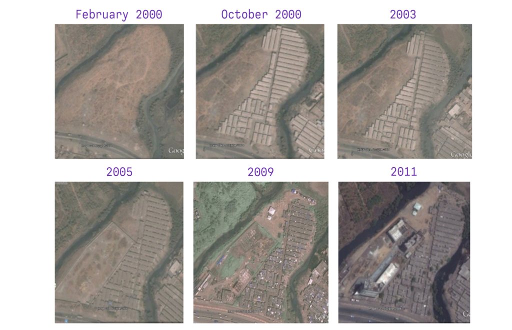
Gradually, the availability, legal recognition, and presumed incontestability of historical earth images led to them being used by the Indian State as a proxy for original proof (e.g., documents) to determine how old settlements are, and if they fall within the cut-off dates. Historical satellite imagery is used to show the nonexistence of settlements before a cut-off date and to justify clearing the land quickly instead of following lengthy, time-intensive procedure of slum clearance. This application has been a prevalent practice in megacities across India since the 2010s (one year after Google Earth launched its historical image slider), but there has been scarce to no mention of this in official, publicly available documents or in research. Yet, its ubiquitous use is common knowledge in my interviews with government officials and remote sensing experts as well as in several news reports since 2010. In Mumbai and Delhi, there are multiple reports on the use of satellite imagery for “slum demolition,”[15]Pooja Domadia, “Satellite Images Used to Demolish Illegal Structure,” Hindustan Times, November 17, 2010, … Continue reading with residents fearing the “eye in the sky” that has fueled the acceleration in demolitions. Similarly in the last decade, there has been a significant uptick in the judiciary relying on satellite images to decide on the rights and entitlements of settlement dwellers, often using it to refute the claims of the occupiers of the land.[16]Vikalp Welfare Society & Ors v. Union of India & Ors, LPA 119/2019 (November 22, 2023). Accessed July 8, 2024, https://indiankanoon.org/doc/47347455/. Further, the courts have pushed for integrating satellite imagery and algorithms to continually monitor the growth of encroachments and stop them, as seen in the Gulab Pushpa Cooperative Housing Society vs. The MCGM case.[17]The Gulab Pushpa Co-Operative Housing … v. The Municipal Corporation of Greater …, Writ Petition. 2474/2018 (October 4, 2018), https://indiankanoon.org/doc/134535257/.
Following the directions in the Gulab Pushpa ruling, in 2021, the MCGM introduced a project to automate the process of identifying settlements built prior to the cut-off dates, as well as detect changes and growth of settlements. As part of the project, first, they have been purchasing very high-resolution (VHR) satellite imagery from 1995 to 2015 for every five years, and then for every subsequent year up to the present and into the future. Second, feature extraction (to extract clusters of settlements and individual dwellings within clusters) is done using object segmentation/classification and machine learning algorithms. This is done with images of all years and is then combined with other attribute data, such as land ownership and land-use planning data. Third, these images are overlaid, and change detection algorithms are used to compare images across time and flag changes. This is integrated with the Removal of Encroachment department of the MCGM to take further action, settle disputes, and track growth. While it’s widely agreed that maps and documents could lie, satellite imagery has a presumption of being truthful and uncontestable. However, these images and algorithms are not as uncontestable as presumed. This is especially important when they are employed to make people homeless.
Shortcomings of Satellite Imagery
The use of historical satellite imagery and algorithms faces three major issues. First, there were issues in the conception of the project itself. Looking at the proposal documents, internal communication, and pre-bid meeting notes, the MCGM wanted to detect all unauthorized construction in the city, which includes bastis, as well as additional floors constructed beyond the permissible limit and unauthorized land use (residential space used for commercial purposes, for example). These goals aimed to address property tax evasion and clear land for development projects or more profitable land use. However, the technology’s limitations hindered the project, shifting the focus from all “unauthorized constructions” to only “illegal encroachments.” These limitations concerned 2D remote sensing imagery, which cannot show building height or tell whether a building is being used for residential or commercial purpose, and the lack of attribute data, which is needed to know what is supposed to be on the land. Further, the cut-off dates are fixed to January 1, 2000, and January 1, 2011. However, there is no control on the temporal resolution of past satellite images. As a result, if images were not collected on December 31, 1999 or 2010, the available image cannot prove or disprove the existence of the settlement or dwelling prior to the official cut-off date.
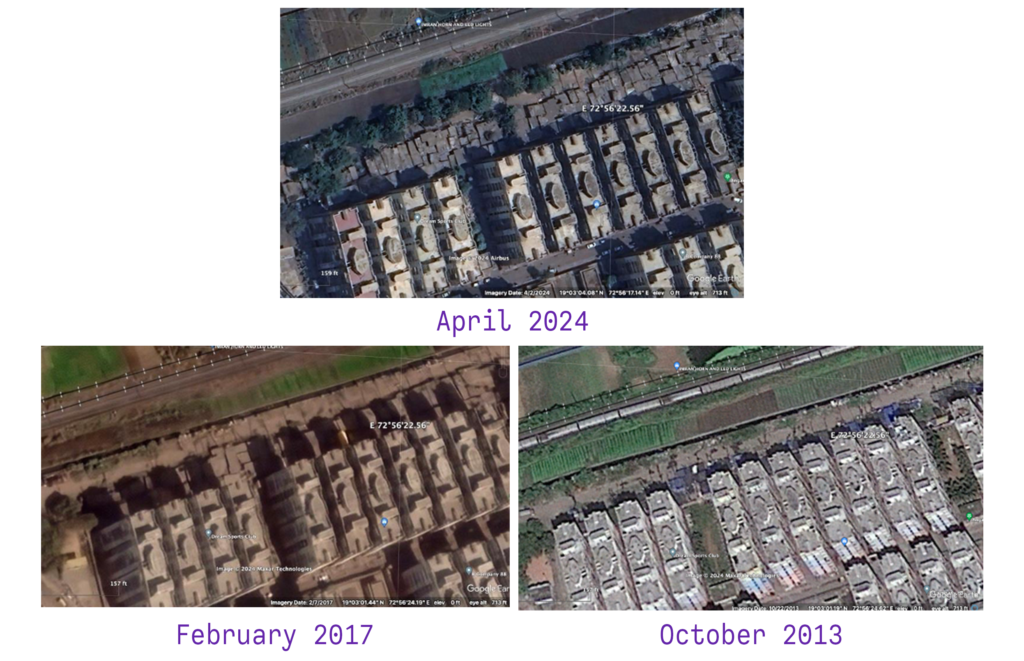
Second, there are the limitations and uncertainties associated with remote sensing images. Commercial satellites like Worldview 3 and 4, which are used in this project, capture panchromatic images with a spatial resolution as small as 30 cm at its nadir (the point where the satellite sensor is at right angle with the ground). With this, the State has moved from simply detecting the growth of settlements, to working to resolve individual dwellings in the settlement. But a 30 cm resolution in an image does not translate to 30 cm on the ground. When comparing images and detecting change, the spatial resolution of older images, especially from the 1990s, is significantly less accurate, up to 80 cm or higher. When standardizing these images for comparison, the overall resolutions need to be reduced. Further, resolution issues come up with the mosaicking,[18]Also called composite, see “Compositing and Mosaicking,” Google Earth Engine, last updated May 30, 2024, https://developers.google.com/earth-engine/guides/ic_composite_mosaic. or stitching together, of images and at points away from the nadir. Thus, composite images are not as reliable as they are often presumed to be, particularly when they include visual information from the 1990s.
Finally, several uncertainties arise when we critically look at the algorithms used for extracting dwelling features and detecting changes. A person changing the roof of their house, or rebuilding the roof or walls after floods or a fire would be flagged as a change even if it’s the same person living in the house. These would require manual correction and extensive ground truthing[19]The process of comparing what’s documented in maps and official documents with the actual conditions at a site. to do correctly. Feature detection algorithms are also highly reliant on training data used to train the classifier to detect dwellings or settlements. This training data comes from preexisting databases of uncertain provenance or is manually created by people with subjective understandings or interpretations of what a slum is.[20]Divyani Kohli, Alfred Stein, and Richard Sliuzas, “Uncertainty Analysis for Image Interpretations of Urban Slums,” Computers, Environment and Urban Systems 60 (November 2016): 37–49, … Continue reading The subjectivity and biases embedded in both these databases can lead to false positives—a structure that is not a basti but is marked as such—and false negatives—a basti that is not marked as such. Importantly, because of the dense nature of informal settlements, even state-of-the-art algorithms using technologies, like Google’s Open Buildings, give several errors when extracting dwelling outlines, and it would require huge amount of manual labor to make corrections. Off nadir there are several issues regarding the shadows of tall objects, position of the sun, the angle at which the image is captured, cloud cover, haze at the time the satellite passes over, leading to pixelated or poor-quality images. Extracting features and detecting change in such conditions (even manually) can easily lead to erroneous results.
Despite these scientific limits, assumptions, uncertainties, and errors, the use of remote sensing images against the urban poor to make them homeless and exclude them from their entitlements raises several observations and questions. As mentioned previously, it allows for bypassing lengthy slum clearance procedures, reduces the disputes on land (even in court cases), reduces the number of R&R beneficiaries, enabling a faster conversion of the land to more desirable or profitable uses.
There is also a huge problem regarding information symmetry with the use of such images. The exact images used by the government are not shared with the people it is used against so that they can verify themselves if it can be used as definitive proof or not. The use of black-box feature extraction and change detection algorithms adds further questions on the fairness, transparency, and accountability of the process. There are several ethical issues with this application as well. Even if such targeting can be done without errors, should they be done? Should slum clearance processes detailed in the law that give dwellers more time, protection, and a chance to contest the orders be bypassed?
Given these issues, as a critical researcher of technology, I have written to the MCGM officials to consider these findings to ensure that algorithm outputs are not used as a basis for demolition, that there is extensive ground truthing, that images used are made public, and to reconsider the application of these images. I also plan to bring my research to housing rights lawyers in Mumbai who fight cases against demolitions, so that cases that use satellite images as a basis can be contested, and the uncertainties associated with using these images can be highlighted. Finally, it is also worth reflecting that historical imagery could be an extremely valuable data source better employed toward understanding how and where cities expand and use it to proactively plan public or migrant housing, rather than only using it punitively to make workers of the city homeless.
Footnotes
